Looking for Precise
Agro-Solution
Use satellite-based farming technology to streamline precision agriculture methodologies.
Explore More

Use satellite-based farming technology to streamline precision agriculture methodologies.
Explore More

It is an innovative Platform that utilises advanced artificial intelligence and machine learning technologies to provide crop monitoring software analytics based on satellite. Our product is designed to cater to a wide range of crops, regardless of their location or the season in which they are grown.
Explore More
Easy and Affordable Tech

Sustainable Agro-Practices

Adaptable to Climate Change

Regenerative Agriculture

Crop Monitoring Services

Crop Monitoring API

Crop Field Boundary Detection
Our mission is to empower India's agriculture with cutting-edge agro-solutions. By providing AI-enabled smart solutions, we strive to enhance yields, optimize resource utilization, and contribute to the prosperity of farmers and the nation.
Our vision is to lead the transformation of Indian agriculture through it's agro-solutions. We envision a future where every farm thrives with the precision of AI, where sustainable practices drive growth, and where our nation's agriculture becomes a global benchmark for efficiency and productivity.

You may improve the economy by implementing excellent solutions used for crop monitoring as well as saving money on resources like fertiliser, water, and labour.

Gain useful insights to strengthen your supply chain and guide your group towards greater efficiency and productivity in delivering and mapping Out new sales territory

Cooperating farmers can increase output and income by sharing resources and coordinating their activities through a central hub.

Insurers, banks, and fintech firms can use satellite imagery to keep tabs on fluctuating crop prices, allowing them to better assess risk and set premiums accordingly

Increase Efficiency

Customised Recommendations

Better Yield

Cost Savings

Early Detection

Improved Decision-Making

Crop Classification

Crop Health Monitoring Satellite based

Crop Health Monitoring Weather based

Irrigation Monitoring

Crop Yield Estimation

Satellite Monitoring

Weather Insights

3-5 Satellite Imagery Revisits

Zoning

1m Ag Satellite Imagery

Farmers Community

Farm Insights

Auto Farm Boundary Detect

Crop Guide

Multiple Language Ready

API Ready

Competitive Market Rates
Helpful solutions that advance climate-smart as well as sustainable agriculture and improve farmers' quality of life.
Collect Photograph, Videos, Location Data, and Save Unwanted Expenses.
Explore More


Use satellite-based farming technology to streamline precision agriculture methodologies. Manage your fields online from your office or home. Know the history of your fields and crop development based on 5 years of imagery and comprehensive list of vegetation indices. In-season imagery allows you:

Crop monitoring

Condition assessment

Recognizing crop emergence anomalies in near-real time

Scout areas with different levels of growth

Look through the clouds
Crop Map based on large amount of processing satellite and climate data, we provide analytical reports and detailed datasets for crop monitoring:
 Crop map
(soy,
corn, wheat, etc.)
Recognized
field boundaries
Climate
data
for regions and particular field
Vegetation
indices statistics by each recognized field
Crop map
(soy,
corn, wheat, etc.)
Recognized
field boundaries
Climate
data
for regions and particular field
Vegetation
indices statistics by each recognized field

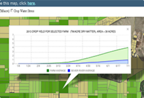
Dashboard is a visual service that helps you to monitor your field states over the year. The service allows to operate with satellite imagery and weather data along with advanced machine learning technologies.
Just draw your polygon on the map and immediately get satellite imagery, NDVI, EVI, NRI, DSWI, NDWI vegetation indices statistics, Hourly and Daily weather forecasts, Historical weather data, Historical NDVI chart and others.
Explore More

A web platform to provide farmers / irrigators with current information about their fields using satellite information.